Landscape of the Sassi - Departure from Miratoio/
(Source: taken from the site of the Sasso Simone and Simoncello Nature Park)
CAI (Italian Alpine Club) trails: 17 - 118 - 61
Time required: 5h 15 min.
The trail starts out from the center of Miratoio, one of the most picturesque villages in the entire area of the Park, as its houses were built almost exclusively using local rock.
In fact, in Miratoio there was a quarry of pietra serena (strongly cemented sandstone) which had been used in construction since ancient times; for example, the stones that were used for the construction of the Palazzo dei Principi in Carpegna came from here.
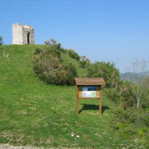
Along CAI (Italian Alpine Club) trail 17 that goes around the Poggio di Miratoio on the right, you enter the military polygon which in summertime is used as a pasture, thanks to its being fenced-in.
After crossing the fence, go up following the ridge through a grazing area made up mainly of rose hip and juniper shrubs.
After the steeper stretch, you come to a huge reddish boulder, called the Sasso Rosso.
This boulder, flanked by a downy oak, which almost acts as if it wants to stop it, is rather unique for its sphere-like shape and its position; it seems, in fact, that it is about to roll at any moment. Continuing on, your gaze is captured by the presence of the Sasso Simoncello with the colorful ravines at its base. It is from this path that you have the opportunity to observe some of the most beautiful of these spectacular modelings of the land by the run-off waters.
Entering the wooded area, you find yourself in the midst of a fairytale landscape, made of twisted trunks of beeches, maples, ash trees, hornbeams and turkey oaks; but also of huge holly bushes.
In spring the undergrowth is rich in primroses and violets, and then gives way to the blossoms of the martagon lily and finally in autumn to the carpets of cyclamen and numerous species of mushrooms.
Arriving at the intersection with CAI (Italian Alpine Club) trail no. 118, continue on to the right until you reach the pass between the two Sassi, known as the cancellino (little gate), perhaps because the border between the Marche and Tuscany regions passes through this point.
From this point, if you leave the main path and head into the clearing on the left, near a great number of boulders, you will be able to observe the summit of Sasso Simone.
Read moreThe path begins to descend, it becomes narrower and remains inside the wooded area until it comes to a clearing, probably caused by a landslide of boulders, from which both Sasso Simone and Simoncello can be seen.
From here it is easy to observe the kestrels that build their nests in the rocky wall in order to go in search of some prey.
Continuing along for a few hundred meters you come out of the woods and skirt other ravines, much richer in rocky fragments.
The landscape in front of you, if you turn left and keep following CAI trail no. 17, is truly unique. A huge rockslide affects the entire southern slope of Sasso Simone and at its foot there is a huge river of rock that extends and descends along the ravines for more than a kilometer.
Often defined as "giants with feet made of clay", the Sassi Simone Simoncello are, in fact, two limestone massifs (formation of San Marino limestone), resting on a layer of clay (formation of Multicolored Clays), the undermining of the base due to the fact that erosion of the run-off water causes a continuous collapsing of boulders that feed the landslide at the base.
Walking across the landslide you can see a great number of fossils.
From here, going up towards Sasso Simone, you can see the large beech tree, standing on the ridge as if it were a sentinel.
Once you have arrived at the beech tree, you can hardly resist the temptation to hug it and sit for a few minutes under its extensive foliage. Its twisted branches testify to the bad weather it has faced during the course of its long life spent guarding the road that leads to Sasso Simone.
The view then turns back onto the Marche side and, on clear days, it is possible to see the sea as far away as Monte Conero.
From here in a few minutes, following what remains of the ancient paved road, you reach the top of Sasso Simone, where you can still see the remains of the famous City of the Sun, built in the mid-sixteenth century by Cosimo I de' Medici.
It is advisable to walk around the entire summit very carefully and not to leave the path; in fact, there are numerous unmarked cracks and crevices.
The 360-degree panoramic view that can be enjoyed from this place explains its history and the ambitious project of making it a city-fortress.
Continue along the trail that leads to Case Barboni.
Go down along the path you followed on the outward journey along the landslide and instead of turning right and going back into the wooded area, continue straight on along CAI (Italian Alpine Club) trail no. 61.
The trail is easily recognizable and takes about 30 minutes to reach the small village of Case Barboni.
It will thus be possible to cross the ravines, which are very similar to those seen on the southern slope of Sasso Simoncello.
When you reach the end of the ravines, near a pass on the left, you need to climb over the fence around the military polygon and go down an old mule trail (on the right there is a weather station).
The peculiarity of the village is a house on the right at the entrance to it, which has a balcony with columns that are thought to have been from the ancient Abbey of Saint Michael which in the Middle Ages had been erected on the summit of Sasso Simone.


